Spot Tracker Review
Here’s the third post in as many weeks reviewing various devices I’ve accumulated over the past year. As always, these are more for long term reference that people find than they are for daily readers. Although I think many of you Ultra and Ironman folks will find this interesting.
A few months ago I was researching options around doing a bike across America trip (a whole post in and of itself) and happened to stumble on a product called a SPOT Tracker. The device allows location information to be automatically sent to a web site via a system not dependent on cell service.
After discussing it with a friend, he decided to pickup the device to allow his son’s scout troop to track the progress of the kids on various adventures (rafting, week long mountain wilderness hikes, etc…). After watching some really cool stuff being done with it over the course of a month, I finally got around to picking on up. So here’s my review of it after a couple months use.
What is it?
The Spot Tracker was originally built to allow adventure seekers to relay position information and signal for help (either to support teams, or directly to 911). However, due to it’s low price point, many different folks have started using it to track progress of long outdoor activities, such as recreational airplane pilots, ATV riders, cyclists, hikers and more. This includes a few fairly prominent folks such as Karl Meltzer’s 45 day Appalachian Trail Hike (recently finished), and the Continental Divide Mountain Bike Race.
![]()
(A screen shot of the mapping page from a friends multi-day hike in the Olympic Mountains near Seattle)
My primary interest aside from being the geek that I am, was to see how practical it would be on long bike rides (7-9+ hours), as well as any other random thing I did (such as my Palau kayaking trip last year). Since I always do my long rides alone on mountainous roads with no cell coverage, I know that certain people (read: my mom) is fairly concerned about my safety during the long rides and would love to be able to see where I am if I haven’t checked in by the end of the day. This would provide her that capability. Here’s a quick overview map that shows where there is coverage. In a nutshell – I’d call the coverage area: ‘Just about anywhere on Earth’.
![]()
The key difference between this and something like the Garmin Forerunner 305 or 405 – is that this is real time live publishing of data points as you go along. Meaning, the Garmin is a post-activity device to see where you went. This Spot Tracker shows other people where you are live. Although you can download your Spot tracks afterwards as well.
The device itself
I picked up the device at my local REI, although you can find it online for slightly cheaper. The device at REI costs just $149 and comes in the below square box. The box is fairly oversized given how small the device itself is. Inside the box is simply the device, two batteries, a small manual and some warranty stuffs.
![]()
Looking at the top of the device, you have a few buttons:
On/Off – This simply turns the device on, or off.
OK – This sends out an “OK” message. There are four types of messages “OK”, “Track”, “Help” and “911”. An OK message is your way of saying “OK” – as in “OK, I’ve reached today’s camp site”.
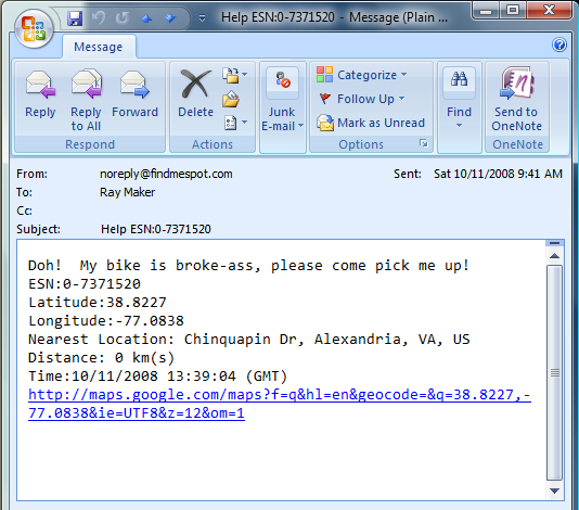
Help – This sends out a “Help” message to a predefined contact that you setup on a webpage. An example is a predefined text or e-mail message to a friend that says “Help, I’ve broke my bike – come get me!”
911 – If held down for 3 seconds, this will send a 911 message to their 911 processing center. From there if they cannot reach you on any of your listed numbers (or emergency contact numbers), they will dispatch 911 and/or emergency responders/rescuers to you.
ON + OK: Pressing these two buttons together for five seconds turns on ‘tracking’ mode, which automatically transmits your location every 10 minutes. This is a ‘track’ message.
A light will blink every few seconds above the On/Off indicator to indicate the device is on. If in tracking mode, a light will also blink above the “OK” button as well. Lastly, lights will light up above the Help and 911 buttons if used.
![]()
If you flip the device over, you’ll notice three little screws to get to the battery compartment. The device itself is waterproof to 10m, so if you drop it into the water – no problemo. One cool thing they did was to create those tiny little handles on the screws so you can easily open them up without a screwdriver. There are also instructions on the bottom of the device for how to use 911 on the device – in case someone finds it next to you and you are unresponsive.
![]()
The clip that you see above easily clips onto a belt, backpack or even the back of a cycling jersey. The device’s size isn’t too big for any of those locations. About the bulk of two decks of cards, or about the size of a standard desktop computer mouse (hey, it’s just what I had handy at the time!).
![]()
(Above: Top view of device. Below: side view of device)
![]()
As for the weight of the device, it’s astoundingly light. Again, about the same weight as that mouse next to it. Overall it’s MUCH lighter than it looks. For additional comparison it’s also about the same weight as a spare tube for your bike (if you were to toss that in your back pocket).
Using the Spot
If you can operate a toilet, you can operate the Spot device. As noted above, there are only four buttons. Of which – only two matter for day to day use – On/Off and OK/Track. To turn it on – you press the on button. And to turn it off you press – gasp – the off button! In roder to protect against accidentally turning it off you are required to hold down the button for a few seconds.
Once you turn it on, it will stay on for weeks up on weeks on two AA batteries. However, it won’t actually transmit anything unless you either press OK to send an OK transmission or turn on track mode. To enable track mode you simply hold down the OK/Track button for about 5-6 seconds. One you do that, it will stay in track mode for 24 hours. It will blink every few seconds to let you know it’s tracking. I’ve found that I can do about 2 weeks of track mode before it runs out of batteries. Normally if you were hiking you’d simply send an “OK” message at the end of the day when you reached camp and then turn the device off for the night. When you just press the OK button is sends a preprogrammed message to a list of preprogrammed contacts. This is also perfect if your trying to arrange food drops along a trail. Below is a copy of a message when you send OK.
![]()
You can place the device just about anywhere. I’ve found that hooking it to the side pockets on a backpack works really well. I have two water bottle holders on my backpack and it works great just chilling in there.
![]()
On my bike I’ve found it works fine either just tossing it into you bike jersey (again, it’s much smaller and lighter than you might think) – or for a more carefree option I simply clip it to my rear water bottle cage system. I would caution however that you do use a small strap to connect it to your bike. I stole one off of an older digital camera and it works well as a ‘safety’. I only mention this because on a ride this summer the device departed my rear water bottle rack at about 35MPH and visited the pavement. The device just fine and dandy – but connecting a ‘safety’ cable would have kept incident from occurring.
![]()
Mapping Site
One of the key draws of the Spot is the ability for you to share your adventure live with friends and family (or your support team). You can create a custom URL/page that your friends and family can go to to see where you are any any OK/Help/911 messages that you may have sent. It will list your location and track, as well as a small altitude/elevation profile. One nice features is that you can have multiple shared pages and can also require a password. In addition, you can make the pages ‘disposable’. For example – say I share a page here on this blog for a long trip to allow folks to see where I am. After the trip I can dispose of that URL and get a new URL within seconds, thus restoring my privacy.
Below are two brief screenshots of the page. As well as the first screenshot of this post in the mountains. You can choose either map/satellite/hybrid or terrain view – with terrain view being by far the coolest (it’s the first picture above).
![]() You’ll note in the above path that because of the frequency of updates (about every 10 minutes) – it appears that I’m not on any roads or paths. Remember that unlike the 305/405 this doesn’t have exact paths being tracked, but rather more waypoints every 10 minutes. Also, sometimes it misses a point. Not a big deal for a hike where you’re moving slowly though.
You’ll note in the above path that because of the frequency of updates (about every 10 minutes) – it appears that I’m not on any roads or paths. Remember that unlike the 305/405 this doesn’t have exact paths being tracked, but rather more waypoints every 10 minutes. Also, sometimes it misses a point. Not a big deal for a hike where you’re moving slowly though.
![]()
Here’s a quick view of the control panel where you can configure the different URL’s and what happens when you press one of the buttons.
![]()
![]()
3rd Party Integration:
The Spot team has done a great job at giving lots of opportunity for folks to develop solutions around the Spot Device. Recently Yahoo introduced their Fire Eagle free service, where folks can update their location based on any number of different applications and devices (such as a cell phone). The Spot Device integrates into Fire Eagle easily with just a few clicks.
![]()
In addition, if you have a bit of programming experience you can leverage Yahoo’s Pipes service to consume the data and offer it up to different applications or services. They have an easy to follow sample that you can start with as a template.
![]()
I took that sample and then played with it a bit and did all sorts of fun stuff in Visual Studio and the default examples in the Virtual Earth SDK. For example, remapping the points using Virtual Earth and automatically displaying them in a Live collection using Birds Eye view.
![]()
At any rate – just wanted to point out there are a ton of flexible things you can do with the data beyond just the simple map views. Oh – and you can download KML track files from the admin page, as well as leverage a live XML and KML feed off their web site for your device.
Help/911/Search and Rescue
For many adventurists, the biggest draw to the Spot device is the ability to call for help – even when there is no cell phone service. Of course, there are typically two different categories of help one might want. One is where you may need assistance – but not emergency assistance. For example, your bike is broken and you need someone to come pick you up. The second is where something has gone really wrong and you need some sort of emergency help (search and rescue, paramedics, etc…). These are divided up into two categories on the Spot Device and thus two buttons.
-
The Help button: As noted earlier, this button will send a preprogrammed e-mail to whomever you specified on the web console. It will include whatever text you choose and to whatever contact(s) you choose. This button is for non-emergency situations. Once you hold the help button down it will keep on sending help updates ever 10 minutes to let folks know of your location (in case your moving). Here’s an example of what it sends to the recipient. The person can click on that link and see the exact location of the Spot device (and thus hopefully – the person). It also lists the nearest location as well.

- The 911 button: This button is for when things really go wrong. For example, you break your leg while out in the wilderness, or you otherwise get yourself into a life or death situation. The button has to be held down for a number of seconds to trigger and it’s not easy to trigger. I’ve not yet had it accidentally depress. Once triggered this starts a chain reaction of events. First a number of pre-programmed emergency contacts are called (including yourself) to see if perhaps it was just an accidental button pressing. This also serves to see if any of those contacts can locate you via other means (such as if you were with a friend, their cell phone). If that fails, then search & rescue and/or paramedics are deployed to look for you based on the position provided. Obviously you can see where the trivial cost of the device instantly pays for itself when you consider the alternative in a wilderness situation. Also – because search and rescue costs are incredibly expensive – you can pay just a couple of dollars to get S&R insurance to cover the costs. If you buy the device – do yourself a favor and pay the latte’s worth extra for the insurance.
Pros/Cons
Here’s a quick list of pro’s and con’s to the device:
Pro’s:
- Satellite tracking of where you are displayed to friends
- No cell phone coverage required, works virtually anywhere
- Simple device, easy to operate – virtually idiot proof
- Amazingly long battery life (2 weeks in 24×7 tracking mode, many more in standby mode)
- Simple AA batteries, nothing expensive or proprietary
- Super small and lightweight, very very durable (I dropped it on the pavement at 35MPH – no issues)
- Easy to use website
Con’s:
- The device could be even smaller, about the size of a cell phone would be awesome
- The back clip has a tendency to vibrate lose if used on a bike, need to screw in really tight
- Some additional features on the web site could go a long way
- Every 10 minutes is great for running/hiking, but having more track points would be cool
What I think this could be in the next generation
I first should say that I’ve exchanged a number of e-mails with developers on the Spot team and have been absolutely blown away by their willingness to hear my feedback and provide me with information and development assistance around the product – awesome job!
While the product is awesome now, I’m really looking forward to what the next generation product could bring. Now I don’t have any inside information, these are just things I’d like to see in the next version:
- Ability to store more track information. For example, even if it uploads every 10 minutes, have it keep track every minute of where you are and upload that information as well.
- Ability to change the upload frequency – even at the expense of battery life. For many of my day trips I don’t need to worry about 14 days worth of battery. I’d rather have the ability to see more data points.
- The ability to see altitude points on the web page (the information is transmitted, just not easy to see)
- What I don’t want to see – is the device getting more complex than it should be from a user standpoint. I love the fact that it’s turn it on and forget it dead simple. I don’t have to worry about it – it just works. I think that obviously over the next few years as the technology improves you’re going to see the ability to effectively merge a Spot device and a Garmin Forerunner device into one unit. But I’m guessing that’s about 24-36 months away. We’re very close, especially with some of the athlete tracking that was just tested at Kona recently.
Where would this be useful?
Well, I’ve been slowly compiling a list of various uses for the device, and here’s a short list I’ve come up with that somewhat relate to sport(s):
- Long bike rides
- Long/Ultra runs (for example, clipped on a Camelback)
- Hiking trips
- Cross Country/Long Road Trips (by car such as to a race)
- River Kayaking/Rafting/Canoeing/etc… trips
- Boating trips
- Backcountry ski trips
This isn’t really meant to be all inclusive, as there are a gazillion other uses (ATV’s, Pilots, etc…), but those were ones that I felt are most applicable to the folks to read my blog.
What I have used it for thus far? Well… I’ve only had it for about two months. But thus far I’ve used it for:
- 8+ hour bike ride
- Many 2-3 hour bike rides
- Some plane flights (it’s very popular within the aviation community)
- Drive up to Ironman Canada
- Playing around on the roads near Penticton (Ironman Canada location)
- Trips up and down the east coast
- Leaving it on my little deck overnight to see what happens
Oh, and to answer whether or not I’d use it during a race…at this point no. Unless we’re talking a fun race or something like a century bike ride/race – but otherwise there are too many other things for me to worry about during a triathlon at this stage. Now…if they shrunk it to have it’s size where it was essentially out of sight/out of mind in my saddle bag and it offered more data points for my family while spectating – then it would be AWESOME for a Half/Full Ironman race.
Summary
In summary – I HIGHLY recommend this device. For the price ($149) and the service (just a few dollars a month), it’s an amazing deal. Especially if you get out of cell service quite a bit, or are in the wilderness where this could be of use if you got into trouble. I know that if I was trail running all the time like SLB or Rambling – I’d definitely pick one of these up and toss it on my backpack/hydration pack. It’s also useful if you’re planning any sort of adventure where you want folks to be able to follow you online- be it in a car across the US, a week long hike in the mountains or backpacking through Europe.
Thanks for reading!


